The description of the catchment hydrodynamic and erosive properties is based on 3 maps :
- Land use
- Runoff axis types
- Soil
These mappings are combined, and hydrodynamic (infiltration capacity, soil depth, etc.) and erosive (erodibility, etc.) properties are defined for each combination. This is the model « parameterization » stage.
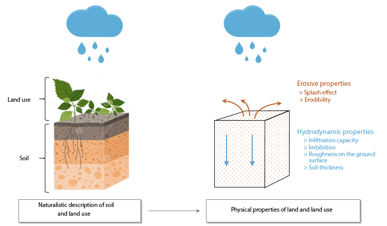
The calculated hydrodynamic properties are:
- Infiltration capacity (mm/h) : limit value of the infiltration rate if the soil is saturated and homogeneous (continuous loss); this infiltration rate depends in particular on the texture and structure of the soil ;
- Manning’s coefficient (s.m-1/3): coefficient reflecting friction forces at the soil surface, as a function of soil roughness and vegetation cover;
The calculated erosive properties are:
- Erodibility (-) : dimensionless coefficient describing the soil’s susceptibility to stripping in the event of concentrated runoff.
- SPM concentration (g/l) : concentration of SPM in runoff water following soil erosion by rainfall due to the « splash effect ».
The various steps involved in constructing hydrodynamic and erosive property grids from shapefile land-use mapping and shapefile soil mapping are detailed in the following tutorials :
Before you start :
- Create the sub-files OCC_SOL, INPUT and REGLES, in the PREPROCESSING file
- Download the tutorial dataset and unzip the file in TUTORIEL/PREPROCESSING/OCC_SOL
- Place nomenclature_occsol.txt, propriete_hydrosed_occsol.txt et regle_imbibition.txt in REGLES

