
Objective
- Runoff and soil erosion modelling
- Simulation of past or future changes in land use or rainfall
- Assessing the impact of measures to combat runoff and soil erosion (soft water schemes, ponds)
Concept
- Hortonian and saturation runoff and groundwater and concentrated erosion
- Sensitivity to runoff linked to structural degradation of the soil surface, under the action of rainfall, land use and soil texture
- “Expert” system for deducing the hydrodynamic and erosive properties of cultivated and natural landscapes
Operation
- Multi-scale distributed model for a given rainfall event or a rainfall sequence
- Mapping of runoff volume,of eroded soil mass, net rainfall height, infiltrated rainfall height, etc.
Data
- Topography (BD ALTI IGN, LIDAR, etc.) + anthropogenic modification of runoff axes
- Land use (RPG, BD TOPO, Corine Land Cover, etc.) + Farming practices
- Soil properties (IGCS, BDAT, etc.)
- Observed / statistical rainfall; Distributed or homogeneous rainfall
Restitution scale
- DTM mesh (0.5m to 25m) adapted to the surface area of the catchment and the modelling objectives
Main limits
- Non-hydraulic model
- Hydrological and sediment balance at event scale
- Velocity approximated by Manning’s equations (approximation of the time dimension)
Implementation
- Plugin in SAGA GIS
- Additional pre- and post-processing plugins in SAGA GIS
- Batch execution from R or CMD

Model objectives
- The WaterSed model (detailled in Landemaine et al., In press) is designed to model runoff, erosion and mudflows at the catchment scale, from the rainfall event to the annual scale.
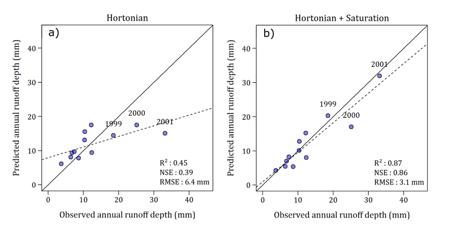
- One of the model originality is that it can be used to simultaneously model infiltration-excess and saturation-excess runoff, associated erosion and sediment transfers.
- It includes so-called « expert rules » taking into account the progressive soil surface degradation under the effect of rainfall (see Grangeon et al., 2022 for details), depending on land use, land cover and soil texture.
- It can be used to model current or future changes in land use / land cover or changes in rainfall regimes
- Latest developments include the possibility to model nature-based solutions for runoff and erosion mitigation (e.g., edges, ponds, grass strips).
Model applications
The model was applied for runoff and erosion modelling in agricultural catchments (Landemaine et al., In press), analysis of water and sediment connectivity (Baartman et al., 2020), scenarios analysis in the case of forest fires (Grangeon et al., 2021) and cascade modelling (Patault et al., 2021).
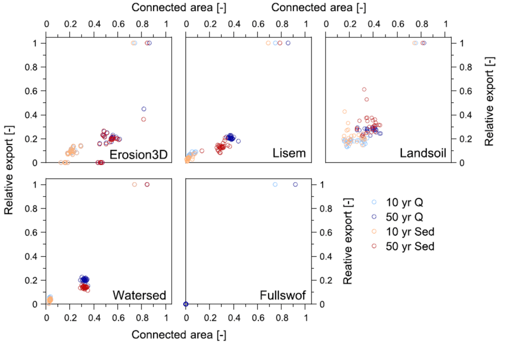
Water and sediment connectivity (Baartman et al., 2020)
In a model comparison exercice performed with European partners, it was demonstrated that functional aspects of connectivity, more particularly rainfall, were more important than structural connectivity. Most importantly, the overall disparate models results regarding landscape organization (e.g., field size, crop allocation patterns, conservation measures) underlined the primordial importance of an adequate parameterization of runoff and sediment production and of routing patterns in models.
Scenario analysis – The case of forest fires (Grangeon et al., 2021)
The WaterSed model was used to characterize the impact of forest fires on the sediment transfers. More generally, effects of erosion « hotspots » on the global catchment dynamics were analyzed. It was shown that they may significantly contribute to the catchments dynamics, underlining the importance of an adequate model parameterization and a correct description of sediment sources in catchment-scale modelling. We also used the model to propose and quantify land management scenarios to mitigate the deleterious effects of forest fires on sediment transfers.

Cascade modelling and scenario analysis – Land use management (Patault et al., 2021)
The WaterSed model was used in a cascade modelling approach with neural networks to model runoff and sediment transfers in a karstic catchment with promising results. Scenarios analysis including changes in farmers practices and the implementation of nature-based solution to reduce runoff and erosion were also performed. Results demonstrated the efficiency of coupling eco-engineering and best management pratices in reducing sediment transfers.

Runoff and erosion modelling in agricultural catchments (Landemaine et al., In press)
In this paper, runoff and erosion were analzed over 12 years in a catchment located in the European loess belt. One of the WaterSed model specificity is that it includes both infiltration-excess and saturation-excess runoff. We used this specificity to demonstrate the importance of accounting for both process even in catchments usually studied using infiltration-excess runoff approaches. It highlighted the importance of continuous simulation to understand catchments hydrological dynamics.
References
Landemaine V., Cerdan O., Grangeon T., Vandromme R., Laignel B., Evrard O., Salvador-Blanes S., Laceby P. In press. Saturation-excess overland flow in the European loess belt: An underestimated process? International Soil and Water Conservation Research.
Grangeon T., Vandromme R., Pak L.T., Martin P., Cerdan O., Richet J.B., Evrard O., Souchère V., Auzet A.V., Ludwig B., Ouvry J.F. (2022). Dynamic parameterization of soil surface characteristics for hydrological models in agricultural catchments. Catena, 214:106257. https://doi.org/10.1016/j.catena.2022.106257
Grangeon T., Vandromme R., Cerdan O., De Girolamo A.M., Lo Porto A. (2021). Modelling forest fire and firebreak scenarios in a mediterranean mountainous catchment: Impacts on sediment loads. Journal of Environmental Management, 289:112497. https://doi.org/10.1016/j.jenvman.2021.112497
Patault E., Landemaine V., Ledun J., Soulignac A., Fournier M., Ouvry J.F., Cerdan O., Laignel B. (2021). Simulating sediment discharge at water treatment plants under different land use scenarios using cascade modelling with an expert-based erosion-runoff model and deep neural network. Hydrology and Earth Systems Sciences, 25:6223-6238. https://doi.org/10.5194/hess-25-6223-2021
Jantiene E.M. Baartman, João Pedro Nunes, Rens Masselink, Frédéric Darboux, Charles Bielders, Aurore Degré, Vincent Cantreul, Olivier Cerdan, Thomas Grangeon, Peter Fiener, Florian Wilken, Marcus Schindewolf, John Wainwright. (2020). What do models tell us about water and sediment connectivity? Geomorphology, 367(15):107300. https://doi.org/10.1016/j.geomorph.2020.107300

